Appalachian Trail

This page is slightly different than our other trip pages in that it covers several
smaller trips concatenated together. These were done scattered over three years
and cover the 76 miles of the Appalachian Trail that runs through Georgia. These
started out as separate pages but it makes more sense to group them together. We followed
the A.T. from south to north in order, although several side trails and nearby locations
are covered as well.

For those who may not be familiar with it, the Appalachian Trail is a hiking trail that
approximately follows the crest of the Appalachian Mountains for more than 2000 miles from
Georgia to Maine. The southern endpoint is Springer Mountain, Georgia where this marker
can be found.

There is no way to get to Springer Mountain except by trail. Even though the A.T. ends
there, a trail continues to Amicalola Falls State Park another four or five miles to the
south. This was to be Trout's first real mountain hike so we began the first day just
by hiking up to Springer Mountain and then back down to the parking lot. By the way, all
I can say about my hair is that is was very windy.

The next day we covered the section between Springer Mountain and an area called Three
Forks where several streams come together to form Noontootla Creek. There are actually
multiple trails that make the trip which is nice if you don't want to backtrack. In the
end, we actually spent as much time playing in the creeks as we did hiking. It wasn't
nearly as dark as this picture makes it look, it was an overcast day though and this
section of the creek was in heavy foliage. Trout meanwhile turned out to be quite the
river dog, though he shows little grasp of some basic concepts.

Like fording for instance. This section of the creek was primarily about a foot deep and
composed of nice calm pools. Trout naturally chose the one rapid in the area through
which to cross. It's not a very big rapid, but still. Notice Trout's tail attempting to
be swept downstream.

Our next hike covered the area from Three Forks to Gooch Gap and back (no shuttle)
over the course of three days. The weather was pleasant. The Chestatee river runs
through nearby Dahlonega although the water was very low at the time. Here Trout stands
in the middle of what would normally be a substantial rapid at higher water levels.

For anyone intending to hike this section, here are some relevant details:
Three Forks to Hightower Gap: Long Falls is a lovely resting spot, otherwise this
section is fairly uneventful. Hightower shelter is nicely situated, there is a
freshwater spring behind it although it's a decent hike. Hightower Gap to Cooper's Gap:
There are a pair of steep mountains along this section - flat stretches are rare.
Halfway in between is Horse Gap. Forest Service road #42 parallels this entire segment.
Cooper's Gap to Gooch Gap: The central part of this section is a relatively low-lying
valley with a couple of creeks - both of which have several nice campsites around them.
One of those campsites, along Blackwell Creek is shown in this photo. Gooch Gap Shelter
is atop a very steep knoll, and the springs are all down around the gap itself. If
you don't need the shelter, there are nice campsites closer to the springs.
FS #42 leads a long way around this section and is not frequently traveled.

Without a shuttle, we hiked north along the Appalachian Trail and then tried to take other
routes back. In some cases this involved other hiking trails in the area (like the Benton Mackaye
Trail), and in other cases it just involved forest service roads. We heard the rushing water
from this cascade on one of these side roads and bushwhacked a bit to find it. It's somewhere
near the source of Justis Creek and it made a nice rest spot.

When we returned several weeks later the weather was not quite as nice. We finished off
the section from Woody Gap to Gooch Gap in the middle of a fog bank. Here, Trout and David
stand only 25 feet (8 m) or so down the trail from Melanie. Trout spooked a young black
bear along this section from a distance. Luckily neither of them wished to investigate
further.

Then next day we did take a shuttle from a friendly member of the local hiking club.
Our original intention was to hike from Woody Gap to Neels Gap. This is a very popular
one or two day hike in the summer as it summits Blood Mountain - the highest point on
the Appalachian Trail in the state of Georgia. The total distance is around 11 miles (18 km).
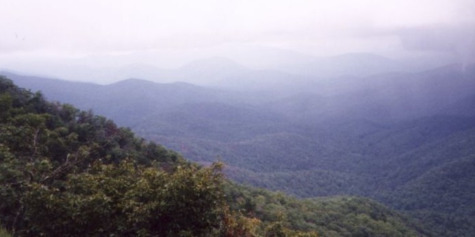
It started off nice enough. This overlook looks out at Woody Gap below.

It wasn't long until the rain started and it continued for the rest of the day.
It made it difficult to stop and rest comfortably and very unpleasant to eat lunch.
It also slowed us down a fair bit. When we reached the base of Blood Mountain we
decided due to continually deteriorating weather to hike around the side rather
than over the top. We strongly suspect there wasn't much of a view up there anyway.

The side trail was less traveled and followed a very narrow ledge at times crossing
through swollen creeks. The rocks became slippery - treacherous in some places like
for instance where we decided to take this picture. The camera was set for a 10 second
delay during which we each nearly fell at least twice. We returned along the side trail
the next year on a much nicer day. We summitted Blood Mountain which was rather crowded as
it is a very popular day hike. From Blood Mountain it is all downhill (literally) to the
Walasi-Yi center and the paved highway.

From Unicoi Gap to HogPen Gap is a relatively uneventful hike until the very last mile.
This tiny little piece is amazingly steep. There's a good campsite on top the knoll which
is nice because the shelter is about a mile off the trail here. This picture was taken at
Unicoi Gap another 14 miles along the trail. The section from Hogpen to Unicoi was our
largest yet (in one day). It's a fairly easy hike although we had a delay due to a stubborn
rattlesnake in the trail, and another delay due to heavy rains. This is approximately
the 50 mile mark of the trail.

After this section we camped at Jenny's Creek Campground which is not too far away in the
vicinity of Helen. It's a family-oriented sort of place but it was comfortable enough.
We also went into Helen one evening for dinner. Helen is a melodramatic mountain town that
has relocated itself to the Alps. We think the town planners who decided to do this hadn't
actually been to the Alps, but it's an interesting result either way. If you can avoid the
hordes of people who have nothing better to do than hang out here on weekends, there seem
to be some decent restaurants.

In July of 2002 we returned to cover the Tray Mountain area. We hiked to Tray Gap
and then camped just off a dirt road nearby. The area is called the Cheese Factory
and has several nice campsites. Don't expect to find a cheese factory though, apparently
there was one here once but there are no traces of it now.

The next day we screwed up our shuttle logistics which had to be fairly accurate, as the
section from Tray Mountain to Dicks Creek Gap is 12 miles long and difficult. We decided
to scrap our hiking plans and spent the day in Tallulah Gorge instead. This is not to be
confused with the state park of the same name farther down the river. The upper section of
the river is located just east of the Appalachian Trail and just south of the North Carolina
border. A small paved road leads into the area and continues as a dirt road farther on.
The campsites here are beautiful in heavy forest along the river. We hiked up the river
(as in, right up the middle of it) for as long as we could manage. The water was cold and
the rocks were slippery but there are several good swimming holes and dozens of small waterfalls.

We returned the next day to cover the rest of the Appalachian Trail to Dicks Creek Gap
and the last road in Georgia. We came across a rather large wild boar at one point but
otherwise we didn't see much wildlife. This happened to be a very hot day and our water
supplies ran low enough that we had to consider filtering at springs along the way.
(We always carry filtration equipment but rarely use it on day hikes). This section includes
a mountain called Kelly Knob which we had been warned about. It is a brutal climb, steep
and fairly long. By the time we reached the top of this we were all tired, even Trout.
Trout injured a paw near the very end of this hike so we had to save the last 8 miles of
Georgia to another weekend.

Well here it is, 8 miles further up the trail this rather unassuming tree has a
wooden plaque on it that you can't really read in this picture but it says Georgia -
North Carolina state line. There's a nice picnic area just a bit farther up the trail.

There may be a barely legible plaque these days, but historically speaking,
hikers know they're in North Carolina when they get to the tree. This is,
the tree. As you can see it is fairly recognizeable as a tree. I must
admit I was unsure at first how we would really know we were there but then
it grows directly in the middle of the trail and well, it is fairly distinctive.
This is technically about 0.1 miles into North Carolina but it's a better landmark
so this where we end the Georgia section of the Appalachian Trail.